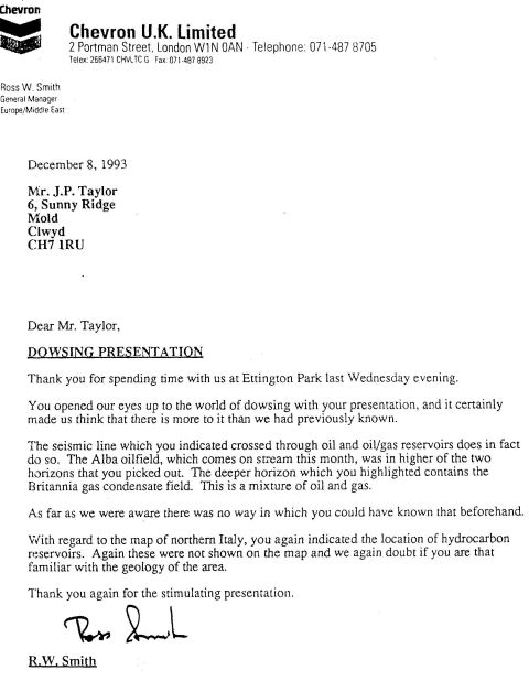
|
The reference above is
linked to the map. During the meeting with the oil company they
asked me to see if I could find anything on a seismic graph. I
located two areas of oil on the graph by map dowsing survey. I also
indicated to them that there was a large gas field at a deeper level
than the oil. They were surprised as this location was kept secret
until December 2nd 1993, the night of my meeting with them. The area
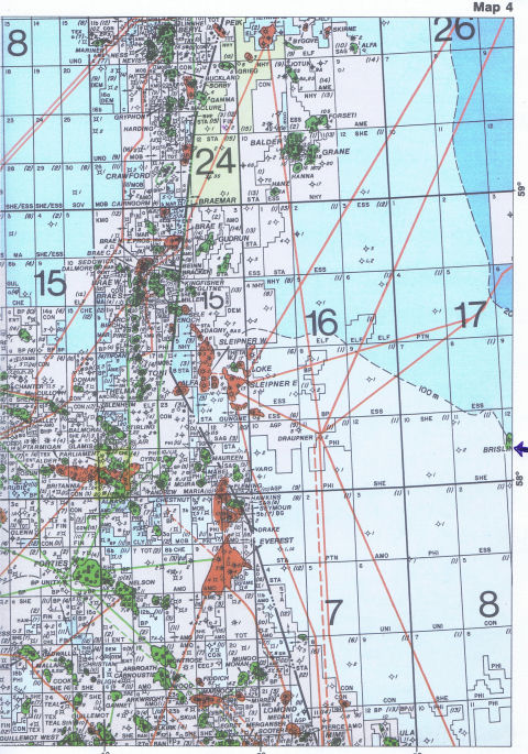
concerned was the licensed area between Parliament and Cyrus which
is highlighted on the two maps below
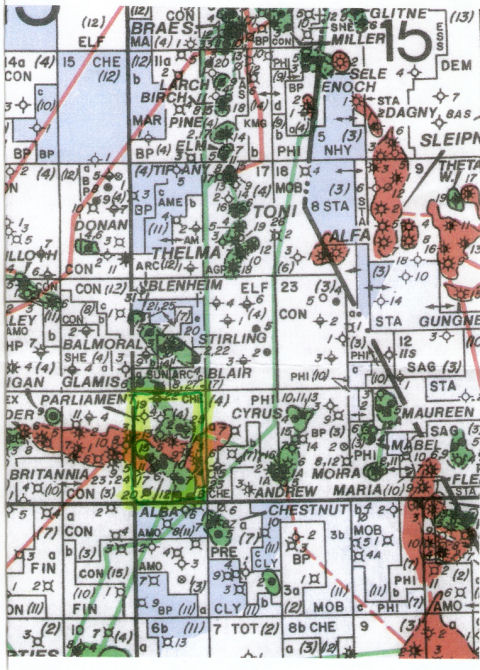
The Britannia oil and gas field is marked in rust colour
stretching east west from Parliament to Cyrus. The alba oilfield is
marked just below it on the eastern side.
Even though there was
no contract between myself and Chevron for the dowsing map survey -
meaning I was not tied to any contract with anyone and I did not
declare this information publicly until 2008.
Britannia gas field
has proved to be a very successful field, being the largest
oil and gas field in the North Sea. At the presentation for
Chevron in 1993 I was able to predict via dowsing a map of the
area that this was a massive oil and gas field and as you can see
from the excerpt below this has proved to be the case
Outlay on Britannia
Britain's largest new gas/condensate field development, could end
up £500 million under the original target figure. Savings have
come from a thorough review of the project at all levels, and
through measures still being suggested by the numerous drilling
and construction alliances. Drilling of a further 27 wells from
the platform and subsea site did start in spring 1998, lasting at
least until spring 2004. The 45 well total is considered
necessary to fully deplete the reservoir over 30 years. The 900
ton subsea manifold, located 15km from the platform will also have
three spare well slots.
Alba oilfield
was one of the two fields of the licensed area and the Britannia
gas field which is a mixture of oil & gas which I picked up on
the seismics graph which Chevron gave me to study whilst I was
with them. I also told them that the oil & gas field was much
bigger than the two oil fields I was picking up and that the oil &
gas field went right across the siesmics graph. As you can see
from the excerpt below this proved to eb the case
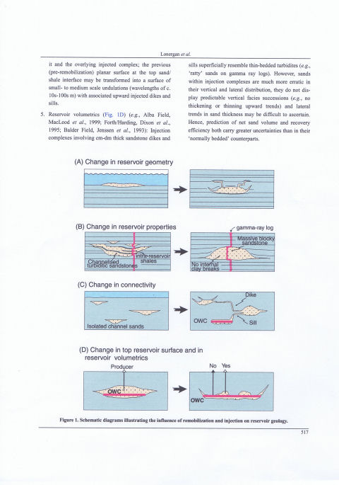
Top reservoir
structure/depth surface (Fig 1D) (the Alba Field) modifications to
the top reservoir surface typically involve a much higher degree
of small-scale structural variability. For example, injection at
the top of a parent sand body results in a potentially highly
irregular contact between it and the overlying injected complex;
the previous (pre-remobilization) planner surface at the
top/sand/shale interface may be transformed into a surface of
small to medium scale indulations (wavelengths of c. 10s - 100s m)
with associated upward injected dikes and sills.............
The Alba
Field
Recently
Lonergan and Cartwright (1999) demonstrated how the narrow
(ca.1.5km), elongate (ca. 12 km long) geometry and shape of the
Eocene Alba Field in Block 16/26 of the Central North Sea has been
significantly modified by polygonal faulting in the surrounding
mudstones and by closely associated sandstone remobilisation.
Polygonal faults are early, compaction related normal faults that
form within layer bound stratigraphic units and are widespread
throughout the deepwater Paleogene successions of the North Sea.
Depositional processes are believed to have been responsible for
the dominantly linear shape and channelised cross sectional
geometry of the main reservoir. However, close observation shows
that the current reservoir geometry is also influenced by the
location of a network of polygonal faults in the surrounding
basinal mudstones. Sheets of injected sandstone occur along
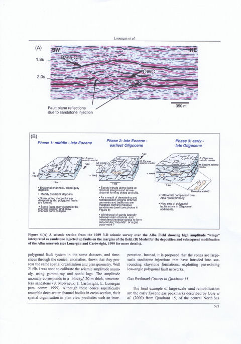
faulted margins of the Alba Field ("wing" structures Fig. 4A) and
follow the trend of the polygonal fault system. This indicates
that polygonal faulting facilitated remobilisation and sand
injection during early burial, which resulted in both modification
of the primary reservoir geometry and redistribution of reservoir
sands. The latter is illustrated by an overlying injection
complex and by adjacent. mounded sand bodies. For example,
isolated 1 km wide, sub-circular mounds to the west of the main
field are attributed to sand withdrawal and remobilisation during
early burial (Fig. 4B). Recently, Chevron and partners have
acquired a new 3-D survey over the Alba field using four component
ocean-bottom-cable technology which has enabled the top reservoir
to be imaged seismically for the first time. These data highlight
more examples of high amplitude "wing" structures along the
reservoir margins and occasionally over the central axis of the
field. Two recent wells have verified that the "wings" visible on
seismic data are injected sands, with one of these injections
comprising a 20 M thick sand layer.
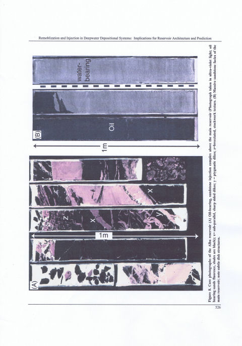
Core from the
Alba field exhibits similar features to those found in Gryphon
core. The cored interval in Figure 8A is an oil bearing,
sandstone injection complex above the main reservoir unit. Note
the sub-panelled, sharp top and bottom of dikes (x), ptygmatic
folding indicating plasticity of the host sediments during
instruction (y), and the stockwork of intimately associated
angular clasts of host mud and intruded sand (z), indicating
explosive brecciation during instruction. Despite the chaotic
nature of the instrusive complex, the oil staining illustrates its
connectivity with the main reservoir beneath. In contrast, Figure
8B illustrates a 3m cored section through the main Alba field
reservoir. The homogeneity and lack of bedding structures within
the sands is most striking; the only sedimentary structures
visible are subtle dewatering related dish structures. This is
one of the most typical reservoir facies encountered in the Late
paleoene. Early Eocene reservoirs in the Central and Northern
North Sea.
With the data now
obtained from drilling the Alba and Britannia oil fields. it is
plain to see that using a map dowser to work on the seismics graphs
alongside a senior geologist can prove beneficial for all parties.
 |
Chevron's fact sheet shows
that my dowsing results were correct; there has proven to be a
large oil field called Alba within the massive oil and gas field at
Britannia.
Click here to see
Chevron Oil fact sheet.
As you can see from the above
fact sheet the Alba oil field is set to produce much more oil just
as predicted by the map dowsing. |
|